Precise mountain peak determination via Smartphone
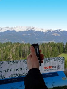
The situation is well known: You arrive at a beautiful viewpoint or mountain summit, enjoy the view and you don’t know what you actually see. The panoramic maps developed by TOURISVIS offer the perfect solution to fix this problem. By implementing the augmented reality technology the info boards, also called panoGipfel, are now further enhanced in order to enable orientation using a smartphone or tablet.
Experience of nature and digital evolution go hand in hand
In practice that means: If a hiker arrives at the viewpoint Tremmelberg (municipality Seckau) he will there find an analogue panoramic map of the surrounding. Through imaged guidance he can download a free application with which he is able to cross-fade the actual surrounding with relevant digital information such as mountain summits, sights, river courses etc. without needing to take his eyes off the actual field of vision. In order to do so he just needs to open the application on his smartphone or tablet, move the device above the panoramic map which is used as an augmented reality marker to exactly pinpoint the location of the device. Hence it is possible to enrich the live camera image with perspective correct 3D information.
New technical approach by using 3D models
Most other GPS based solutions are, depending on the GPS signal and eventual fault effects, too inexact to precisely pinpoint for instance mountain summits. Instead of using the geo-information of the mobile device to identify the actual position, the application presented here takes this information from a deposited 3D model. Hence it is possible to display 3D information for instance street courses or the structure of buildings in a correct perspective.

